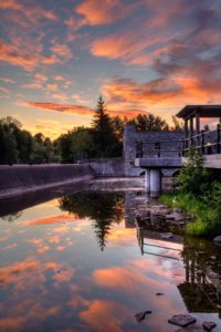
In an alternate timeline, I stayed in Lindsay, Ontario back in the 1990’s instead of leaving to live closer to the GTA. If I had stayed, as human nature is, I probably would hate it now. Being a tourist now, it’s just not that bad.
I can tell one thing, in the handful of years I lived in town, I’m positive I never got up for a sunrise. I’m absolutely certain I never dipped my toes into the waters of the Scugog River.
So, a few weeks ago, I did both. Honestly, I wasn’t expecting the skies to be as brilliant before sunrise as they were. The plan was to simply go for a kayak on the Scugog and capture the video below. But, as I drove southwest out of Bobcaygeon, I could see the clouds and light mingling perfectly. I got to Lock 33 of the Trent Severn Waterway just in time.
Lindsay, Ontario Sunrise Image Gallery
It wasn’t perfect. If I had more time, I would have set up on the north side of the locks for some better views. The bridge was under construction, so I made the best of the south side.
For full-size versions of the photos in the image gallery, simply click on the individual pictures. The lens used for all was a Tamron 18-200mm zoom lens.
High resolution versions of these images and other photos from the same day are available at Dreamstime. Want to earn cash from your own photos? Why not sign up for free with Dreamstime and start submitting now: Become a paid photographer!
Paddling The Kawarthas In Lindsay, Ontario [Video]
After the photos were taken and the pre-sunset colour was gone from the sky, I headed to the boat launch at Nayoro Park and paddled back to the locks in my Pelican Magna 100 kayak.
If you like what you see, please give the video a ‘Thumb’s Up’. We’d be forever grateful if you’d subscribe to our YouTube Channel!
Video edited with Corel VideoStudio Ultimate 2018.
About Lindsay, Ontario
Now the seat of the City of Kawartha Lakes, Lindsay was established as a town in 1831. Just over 20,000 residents live within the traditional borders of Lindsay. The population of the City of Kawartha Lakes is around 75,000.
Running through town is the Scugog River, connecting Sturgeon Lake to the north with Lake Scugog to the south. Lock 33 of the Trent Severn Waterway is located in the centre of town and allows boaters to travel between these two lakes. This is a spur and you cannot travel any further by boat past Scugog.
Not only is the waterway at this point limited by destination but it’s limited by boat size. As you can see in the video, there are two walking bridges up stream from the locks. The shortest, and closest to the locks, has a clearance of just 3.7 metres or 12 feet. This means the typical house boats that crowd the rest of the canal cannot pass.
Of course, limiting the waterway also makes it a bit more peaceful for paddling. I did not encounter a single motorized boat on a journey that took me from the launch, to the locks then out and back to the highway 7 bridge. In fact, there was only one boat moored at the locks, in stark contrast to the crowds at nearby Fenelon Falls and Bobcaygeon.
The lift at Lock 33 is just 2.1 metres. It is unique in that the doors are operated by human power. Two workers spin around large handles to open and close the gates.
The shell of a building seen in the photos and video is an old historic saw mill that burnt down. The building has been preserved as part of a riverfront park.


