

Letchworth State Park
Upper Genesee Falls and Portage Viaduct
Middle Genesee Falls
Inspiration Point
Lower Genesee Falls
Mt. Morris Dam
Letchworth Park Video
Barber House Ruins
Letchworth State Park
Letchworth State Park is located in the northwestern portion of the state of New York. The park is located 35 miles south of Rochester and 60 miles southeast of Buffalo, NY. For Canadians, the drive from Toronto can be as short as 2.5 hours, depending on traffic and delays at the border. This makes it an equidistant camping and outdoors option to Algonquin Provincial Park.
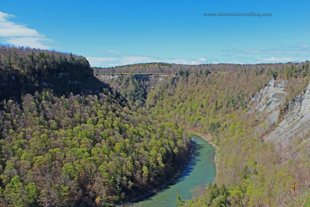
The park contains 14,350 acres of land in a narrow strip of both sides of the Genesee River. From end to end, the distance is around 17 miles. The distance from the main camping area to the main waterfall attraction area is a lofty 11 to 12 miles.
Dubbed the ‘Grand Canyon of the East’, the steep rock walls on either side of the river reach heights of up to 550 feet above the river bed. Along this stretch are the featured attractions, the three main waterfalls reaching heights of 70 to 107 feet.
As mentioned, the campground is a good distance from the main attractions. However, each of the 270 sites at Highbanks Tent and Trailer Area are roomy, treed and come with electrical hookups. For my Canadian friends, and those Americans not from New York, there is a $5 per night surcharge for all out of state visitors per campsite. This is New York State Park policy and not one I agree with but whatcha gonna do?
There are also 81 cabins throughout the park available for rent and there are other lodgings at a handful of inns.
The ball got rolling on this state park back in 1856. That was the year William Pryor Letchworth bought a 1,000 acre parcel of land adjacent to the middle falls. He built a still standing historic inn on the site. In 1906, four years before his death, William gave the estate to the state of New York. In 1907, Letchworth State Park was created.
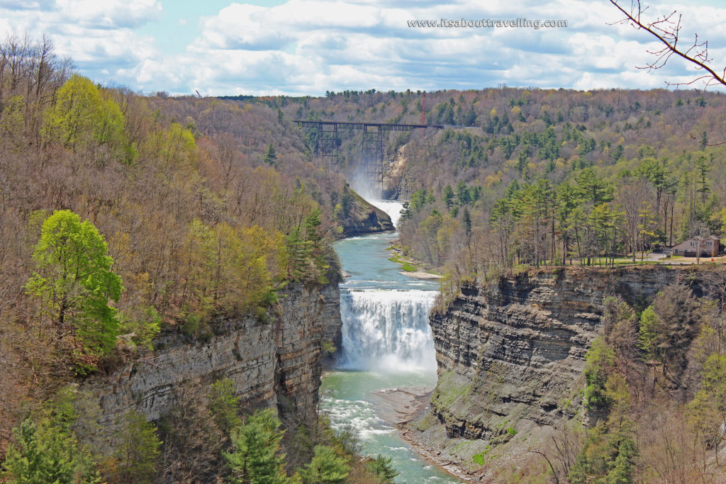
Upper Genesee Falls and Portage Viaduct
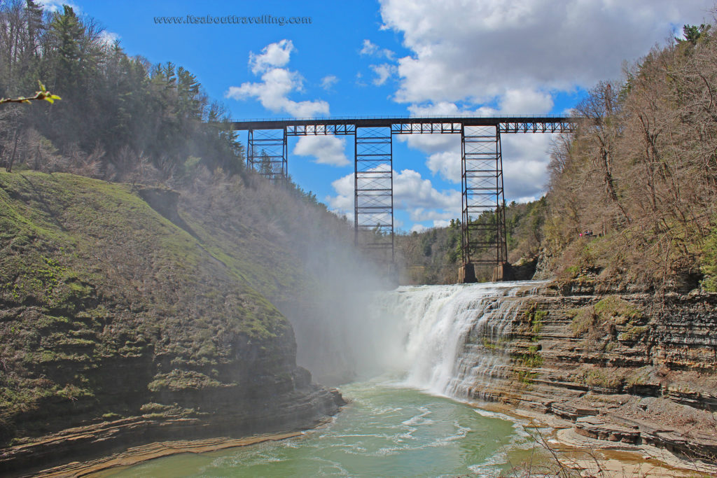
The upper falls are located just downstream from the historic Portage Viaduct. This is classified as a horseshoe cascade and is 70 feet in height. The crest is also 70 feet. Known as Upper Genesee Falls, along with Upper Letchworth Falls, or just Upper Falls, this waterfall may not be the biggest but it certainly may be the most picturesque.
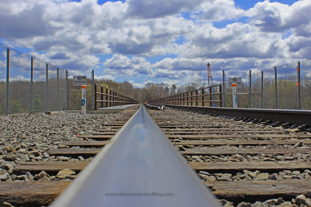
The Portage Viaduct is the train bridge seen above the waterfall. This steel bridge was constructed in 1875 and is 820 feet long with a height of 240 feet. The railway is owned by Norfolk Southern Railway. There are plans to demolish the bridge with a new one already under construction just 75 feet upstream.
We did a little off trail hiking to get to the edge of the bridge, seen below. However, we honoured the ‘No Trespassing’ signs and did not cross the bridge – mostly because we could hear train horns in the distance. It seems that ignoring the signs is fairly popular and from what I’ve seen, the overhead view of Upper Genesee Falls is spectacular.
There is some sort of movement to stop the destruction of this historic structure and convert it to a walking bridge. Funding of upgrades seems to be a sticky point. For more info on the history, Rochester Subway is a great website with massive details on this and many more treasures in upstate New York.
Middle Genesee Falls
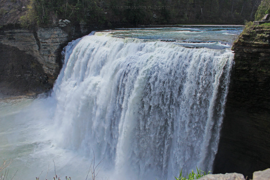
This is the ‘Niagara Falls’ of the three. Middle Falls is located steps away from the Glen Iris Inn, the building that started it all back in the 1800’s. The waterfall is 107 feet in height and has a crest of around 200 feet. There are several vantage points from where to view the waterfall and it is illuminated at night, a la Niagara Falls.
Inspiration Point
Inspiration Point is an area not far downstream from Middle Falls. This is the location of Inspiration Falls, by some standards, the highest waterfall in New York state at 350 feet. However, it is nothing more than a drain pipe that flows only during heavy rainfall. It can be seen from the west side of the river as a few feet of spray before disappearing below the top of cliff. From the west side, it appears as a wet stain on the rock.
This is still worth a stop and look, though. Inspiration Point offers a unique view of both Middle and Upper Falls, along with the Portage Viaduct.
By the way, Taughannock Falls, not far to the east, is widely considered New York’s tallest waterfall.
Lower Genesee Falls
For me, this was the main event. Lower Falls is a 70 foot cascade waterfall with a crest that fluctuates in and around the 150 foot mark. The draw was the unique shape and the fact that you could easily go renegade and put your fingers right in the crest as it falls into the void.
Of course, we did get in trouble here by a park worker. I couldn’t hear him that great over the sound of the waterfall but he mentioned something about a girl being paralyzed in an incident on the very spot just two years before. He was a good guy, though, and seemed generally concerned about the safety of the visitors.
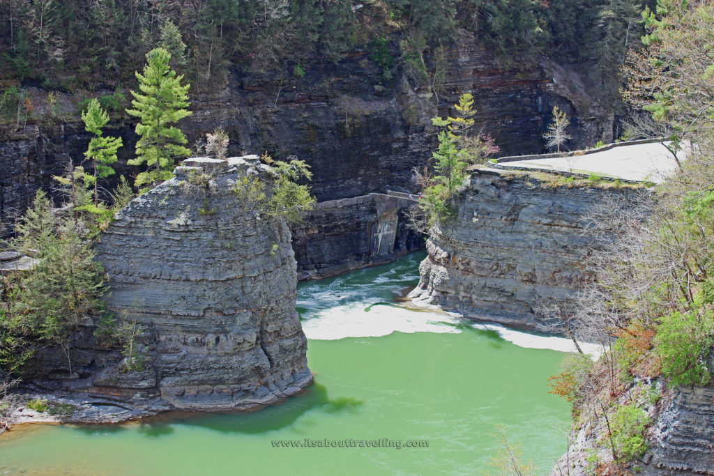
Just below the lower falls is the only bridge that crosses the river within the park. A simply stone arch crosses that very fast moving waters of the Genesee River between Table Rock and Cathedral Rock. It’s said that as recent as the 1800’s, the lower falls was located at this point. The stone walking bridge is similar to the Lord of the Rings type scene you find at not so far away Watkins Glen in the centre of the Finger Lakes Region.
Cathedral Rock is another popular trespassers spot in the park. You’re not supposed to climb but there was never a point when we didn’t see at least a person at the top.
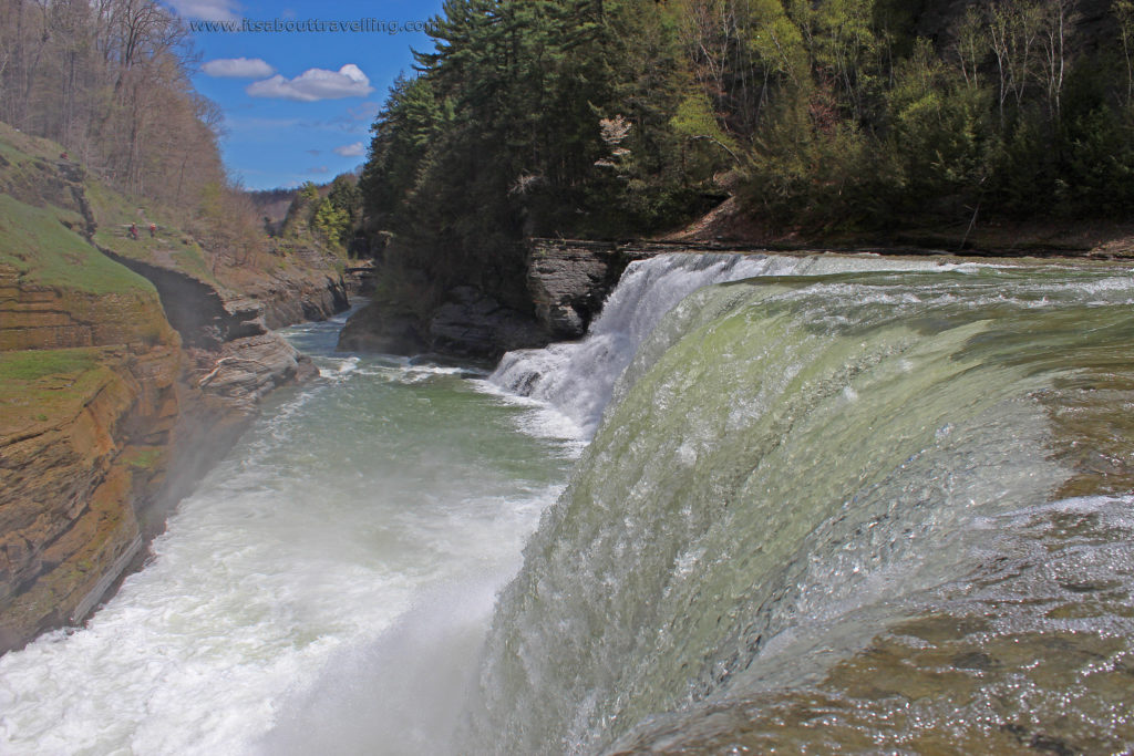
The above picture shows the edge of Lower Falls right at the crest. The image below is of Cathedral Rock to the left and Table Rock to the right with the stone arch bridge visible in the middle.
Mt. Morris Dam
Mt. Morris Dam is located near the northern end of the park, between Highbanks Tent and Trailer Area and the Mt. Morris entrance. Completed in 1952 by the United States Army Corps of Engineers, this a flood control dam and not for hydro electric generation. Typically, the level of the river is the same on either side of the dam, unless there is high chance of flooding.
The Genesee River flows into Lake Ontario at Rochester, New York. Without the dam, it is said there would have billions of dollars damage to the city throughout the years. The river has it’s headwaters in Northern Pennsylvania and is 157 miles long.


After Hurricane Agnes in 1972, the dam was at its fullest it has ever been. The waters held back nearly reached the top of the canyon. Below, there is an image of Hog’s Back Ridge, a unique formation not far upstream from the Mt. Morris Dam. In 1972, with the Hurricane Agnes flood water, the ridge was reduced to a thin island, barely showing above the waterline.


The HD Video below shows Letchworth State Park and its three main waterfalls in much greater detail. Take a look, if you like what you see, give it a thumb’s up and share it with friends!
Letchworth State Park Video

Barber House Ruins
Speaking of trespassing… If you are visiting Letchworth State Park and want to see something really cool, and more than a bit spooky, you should drive by the Barber House, aka the Gath Mansion. This is an abandoned mansion from the 1800’s that may have just a few short years left before it’s gone. Yes, it’s on private property. Yes, this doesn’t deter people from checking it out and it didn’t stop us. Take a look at our images, along with more detailed information, here: The Barber House Ruins
