


Typically, because there simply isn’t much traffic (you could easily go an hour on some of the main highways without seeing another vehicle), the larger rivers are crossed by ferry. Up until 2012, the main highway connecting capital and largest city Yellowknife to the rest of the world crossed the MacKenzie River by ferry in the summer and by ice bridge in the winter.
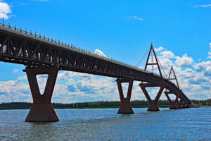
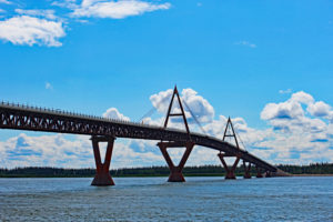
Now, a mammoth in the middle of nowhere, the Deh Cho Bridge (MacKenzie River Bridge), spans the mile wide river at Fort Providence, putting the ferry boat out of business. Deh Cho is Dene for MacKenzie River.
The images in the gallery below were taken at the start of July, 2016. Click on the individual images for the full size version. Below the image gallery is more information on the bridge, river and Fort Providence.
Deh Cho Bridge Image Gallery


Deh Cho Bridge
Construction began in 2008 and on November 30, 2012, the Deh Cho Bridge spanned the MacKenzie River. The bridge is 1.1 kilometres long while it actually spans across the 1.6 kilometre wide river. This is part of the Yellowknife Highway or Highway 3, connecting the MacKenzie Highway with Yellowknife. It is also called the Great Slave Highway as it wraps around the west end of Great Slave Lake.
Prior to 2012, the river was crossed in the warmer months by the ferry boat MV Merv Hardie. In the winter, the river was traversed via an ice bridge or ice road. The Deh Cho Bridge has nine spans with eight steel piers. There is a toll to cross but only for trucks. Non-commercial vehicles do not pay.
MacKenzie River
The MacKenzie is the largest and longest river system in Canada. Including tributaries like the Liard River, this is one of the longest rivers in the world – sitting at 13th. From Great Slave Lake, the river travels 1,738 km or 1,080 miles to the Beaufort Sea and the Arctic Ocean. At Fort Simpson, the MacKenzie merges with the Liard River and is a sight to see.
The MacKenzie River drainage basin is the largest in Canada. Nearly 20% of the country’s waters drain through this system.
Fort Providence
The town of Fort Providence is not far up the Yellowknife Highway from the junction with the MacKenzie Highway. There are so many towns in the Northwest Territories that start with ‘Fort’ and I’ve learned if you want to talk like the locals, you simply drop the ‘Fort’.
Population is around 750 and there is limited commerce including a gas station, a few restaurants and a store or two. The local population is largely made up of Dene and Metis First Nations people.
Summer time is really not much different here than it is in southern parts of Canada. The July average daytime high temperature is 23.5C and the record high came in at 36.1C. However, in the winter, the January average high is a bone chilling -19C with the record low temperature coming in at -50C.
Keep in mind, you’re not quite to the Arctic Circle but daylight hours are extreme. In late June and early July, you might as well say there is no nighttime. Sun sets after 11pm and rises just a short time later. In between, it’s no darker than twilight.
